Integrated Sponge City Approach for Kosasthalaiyar Basin
Systematizing blue-green infrastructure across 170 acres into 3 street tiers and 3 open-space types.
- 170Acres in the feasibility study area
- 3Street tiers systematized — primary, secondary, tertiary
- 3Open-space categories — major, local, wasteland
- 6Person design team
Problem
Chennai’s grey stormwater infrastructure was not built for the rainfall the city now sees. The Kosasthalaiyar basin needed a feasibility study for blue-green infrastructure (BGI) and nature-based solutions that could actually be layered onto an existing, dense residential grid — not a clean-slate redesign, but a retrofit strategy for streets, open spaces, and private plots as they already exist around MMDA Colony.
Approach
As design and technical lead, I co-led the team through a Detailed Feasibility Report and Technical Project Report for a ~170-acre study area, and a Detailed Project Report for a sponge-park pilot site within it. Detailed runoff coefficients and dynamic modeling in EPA’s Stormwater Management Model (SWMM) quantified what each intervention would actually do to runoff, rather than relying on rule-of-thumb estimates.
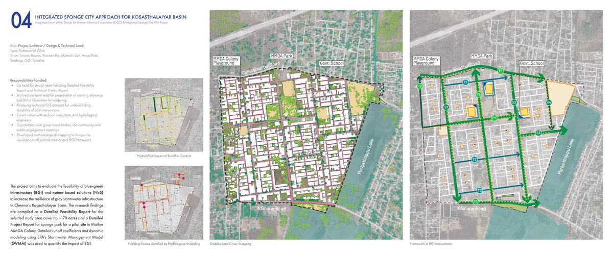
| Source | Product | Access |
|---|---|---|
| EPA SWMM | Dynamic runoff-coefficient modeling | Applied to quantify BGI impact |
| Hydrological modeling | Flooding-node identification in stormwater conduits | Team-developed methodology |
| Site survey and GIS mapping | Detailed land-cover classification | Field survey + desk GIS |
Results
The interventions are systematized rather than bespoke: three street tiers — primary, secondary, tertiary — each get a matched catalogue running from simple (tree planting, bioswales) to advanced (rain gardens with storage, rainwater harvesting), and three open-space types — major, local, and wasteland — get the same simple-to-advanced treatment scaled to their size and existing condition.
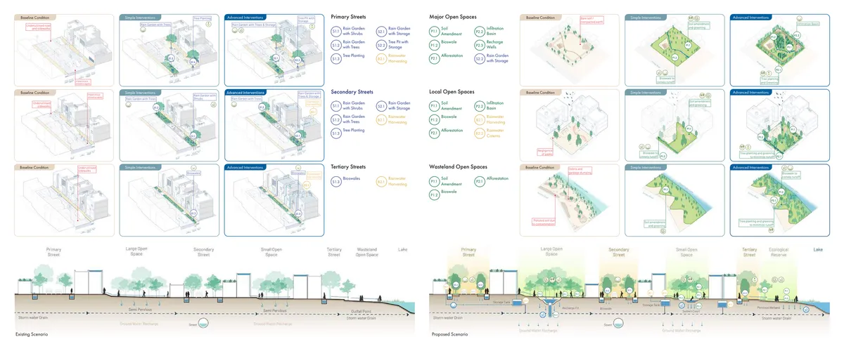
The street-section comparison makes the payoff legible end to end: the existing scenario routes everything to a storm drain and an outfall point: the proposed scenario intercepts water at every stage — storage tanks, recharge pits, bioswales, sunken courts — before it ever reaches the lake.
What I’d do differently
The feasibility report quantifies runoff reduction per intervention type but not the maintenance burden each one adds for the corporation that has to keep it working after handover. A five-year operations cost alongside the capital cost would make the simple-versus-advanced choice a genuine trade-off rather than an obviously-better one.
Share this page
https://abdulkalam.pages.dev/projects/kosasthalaiyar-sponge-city/
Scan to open this page. Download the SVG for print.
